- Sint Maarten
-
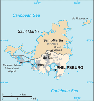 Introduction ::Sint MaartenBackground:Although sighted by Christopher COLUMBUS in 1493 and claimed for Spain, it was the Dutch who occupied the island in 1631 and set about exploiting its salt deposits. The Spanish retook the island in 1633, but continued to be harassed by the Dutch. The Spanish finally relinquished the island of Saint Martin to the French and Dutch, who divided it amongst themselves in 1648. The establishment of cotton, tobacco, and sugar plantations dramatically expanded African slavery on the island in the 18th and 19th centuries; the practice was not abolished in the Dutch half until 1863. The island's economy declined until 1939 when it became a free port; the tourism industry was dramatically expanded beginning in the 1950s. In 1954, Sint Maarten and several other Dutch Caribbean possessions became part of the Kingdom of the Netherlands as the Netherlands Antilles. In a 2000 referendum, the citizens of Sint Maarten voted to become a self-governing country within the Kingdom of the Netherlands. The change in status became effective in October of 2010 with the dissolution of the Netherlands Antilles.Geography ::Sint MaartenLocation:Caribbean, located in the Leeward Islands (northern) group; Dutch part of the island of Saint Martin in the Caribbean Sea; Sint Maarten lies east of the US Virgin IslandsGeographic coordinates:18 4 N, 63 4 WArea:total: 34 sq kmcountry comparison to the world: 236land: 34 sq kmwater: 0 sq kmnote: Dutch part of the island of Saint MartinArea - comparative:one-fifth the size of Washington, DCLand boundaries:total: 15 kmborder countries: Saint Martin (France) 15 kmCoastline:364 kmMaritime claims:territorial sea: 12 nmexclusive fishing zone: 12 nmClimate:tropical marine climate, ameliorated by northeast trade winds, results in moderate temperatures; average rainfall of 1500 mm/year; hurricane season stretches from July to NovemberTerrain:low, hilly terrain, volcanic originElevation extremes:lowest point: Caribbean Sea 0 mhighest point: Mount Flagstaff 386 mNatural resources:fish, saltLand use:arable land: 10%permanent crops: 0%other: 90% (2011)Irrigated land:NANatural hazards:subject to hurricanes from July to NovemberEnvironment - current issues:NAGeography - note:the northern border is shared with the French overseas collectivity of Saint Martin; together, these two entities make up the smallest landmass in the world shared by two self-governing statesPeople and Society ::Sint MaartenLanguages:English (official) 67.5%, Spanish 12.9%, Creole 8.2%, Dutch (official) 4.2%, Papiamento (a Spanish-Portuguese-Dutch-English dialect) 2.2%, French 1.5%, other 3.5% (2001 census)Religions:Roman Catholic 39%, Protestant 44.8% (Pentecostal 11.6%, Seventh-Day Adventist 6.2%, other Protestant 27%), none 6.7%, other 5.4%, Jewish 3.4%, not reported 0.7% (2001 census)Population:39,689 (July 2013 est.)country comparison to the world: 212Age structure:0-14 years: 19.7% (male 3,986/female 3,704)15-24 years: 16.3% (male 3,130/female 3,253)25-54 years: 45.3% (male 8,626/female 9,077)55-64 years: 12.9% (male 2,448/female 2,596)65 years and over: 5.8% (male 1,087/female 1,181) (2013 est.)Median age:total: 39.7 yearsmale: 38.9 yearsfemale: 40.4 years (2013 est.)Population growth rate:1.51% (2013 est.)country comparison to the world: 79Birth rate:13 births/1,000 population (2013 est.)country comparison to the world: 153Death rate:4.51 deaths/1,000 population (2013 est.)country comparison to the world: 200Net migration rate:6.63 migrant(s)/1,000 population (2013 est.)country comparison to the world: 17Sex ratio:at birth: 1.05 male(s)/female0-14 years: 1.08 male(s)/female15-24 years: 0.96 male(s)/female25-54 years: 0.95 male(s)/female55-64 years: 0.94 male(s)/female65 years and over: 0.92 male(s)/femaletotal population: 0.97 male(s)/female (2013 est.)Infant mortality rate:total: 9.05 deaths/1,000 live birthscountry comparison to the world: 151male: 9.84 deaths/1,000 live birthsfemale: 8.22 deaths/1,000 live births (2013 est.)Life expectancy at birth:total population: 77.61 yearscountry comparison to the world: 63male: 75.34 yearsfemale: 79.99 years (2013 est.)Total fertility rate:2.09 children born/woman (2013 est.)country comparison to the world: 113HIV/AIDS - adult prevalence rate:NAHIV/AIDS - people living with HIV/AIDS:NAHIV/AIDS - deaths:NAEducation expenditures:NAGovernment ::Sint MaartenCountry name:Dutch long form: Land Sint MaartenDutch short form: Sint MaartenEnglish long form: Country of Sint MaartenEnglish short form: Sint Maartenformer: Netherlands Antilles; Curacao and DependenciesDependency status:constituent country within the Kingdom of the Netherlands; full autonomy in internal affairs granted in 2010; Dutch Government responsible for defense and foreign affairsGovernment type:parliamentaryCapital:name: Philipsburggeographic coordinates: 18 1 N, 63 2 Wtime difference: UTC-4 (1 hour ahead of Washington, DC during Standard Time)Administrative divisions:none (part of the Kingdom of the Netherlands)Independence:none (part of the Kingdom of the Netherlands)National holiday:Queen's Day (Birthday of Queen-Mother JULIANA and accession to the throne of her oldest daughter BEATRIX), 30 April (1909 and 1980)Constitution:Staatsregeling, 10 October 2010; revised Kingdom Charter pendingLegal system:based on Dutch civil law system with some English common law influenceSuffrage:18 years of age; universalExecutive branch:chief of state: Queen BEATRIX of the Netherlands (since 30 April 1980); represented by Governor General Eugene HOLIDAY (since 10 October 2010)head of government: Sarah WESCOTT-WILLIAMS (since 10 October 2010)cabinet: Cabinet(For more information visit the World Leaders website )elections: the monarch is hereditary; governor general appointed by the monarch for a six-year term; following legislative elections, the leader of the majority party is usually elected prime minister by the legislatureLegislative branch:unicameral parliament or Staten (15 seats; members elected by popular vote for four-year term)elections: last held 17 September 2010 (next to be held in 2014)election results: percent of vote by party - National Alliance 45.9%, UPP 36.1%, Democratic Party 17.1%, other .9%; seats by party - National Alliance 7, UPP 6, Democratic Party 2Judicial branch:highest court(s): Joint Court of Justice of Aruba, Curacao, Sint Maarten, and of Bonaire, Sint Eustatitus, and Saba or ""Joint Court of Justice"" (consists of the presiding judge, other members, and their substitutes); final appeals heard by the Supreme Court, in The Hague, Netherlandsnote - prior to 2010, the Joint Court of Justice was the Common Court of Justice of the Netherlands Antilles and Arubajudge selection and term of office: Joint Court judges appointed by the monarch for lifesubordinate courts: Courts in First InstancePolitical parties and leaders:Democratic Party or DP [Sarah WESCOTT-WILLIAMS]National Alliance or NA [William MARLIN]United People's Party or UPP [Theodore HEYLIGER]Concordia Political Alliance or CPA [Jeffery RICHARDSON]Diplomatic representation in the US:none (represented by the Kingdom of the Netherlands)Diplomatic representation from the US:the US does not have an embassy in Sint Maarten; the Consul General to Curacao is accredited to Sint MaartenFlag description:two equal horizontal bands of red (top) and blue with a white isosceles triangle based on the hoist side; the center of the triangle displays the Sint Maarten coat of arms; the arms consist of an orange-bordered blue shield prominently displaying the white court house in Philipsburg, as well as a bouquet of yellow sage (the national flower) in the upper left, and the silhouette of a Dutch-French friendship monument in the upper right; the shield is surmounted by a yellow rising sun in front of which is a Brown Pelican in flight; a yellow scroll below the shield bears the motto: SEMPER PROGREDIENS (Always Progressing); the three main colors are identical to those on the Dutch flagnote: the flag somewhat resembles that of the Philippines, but with the main red and blue bands reversed; the banner more closely evokes the wartime Philippine flagNational anthem:name: ""O Sweet Saint Martin's Land""lyrics/music: Gerard KEMPSnote: the song, written in 1958, is used as an unofficial anthem for the entire island (both French and Dutch sides); as a collectivity of France, in addition to the local anthem, ""La Marseillaise"" is official on the French side (see France); as a constituent part of the Kingdom of the Netherlands, in addition to the local anthem, ""Het Wilhelmus"" is official on the Dutch side (see Netherlands)Economy ::Sint MaartenEconomy - overview:The economy of Sint Maarten centers around tourism with nearly four-fifths of the labor force engaged in this sector. Nearly two million visitors come to the island each year by cruise ship and roughly 500,000 visitors arrived through Princess Juliana International Airport in 2012. Cruise ships and yachts also call on Sint Maarten's numerous ports and harbors. No significant agriculture and limited local fishing means that almost all food must be imported. Energy resources and manufactured goods are also imported. Sint Maarten had the highest per capita income among the five islands that formerly comprised the Netherlands Antilles.GDP (purchasing power parity):$798.3 million (2010 est.)country comparison to the world: 209$794.7 million (2008 est.)$748.9 million (2007 est.)GDP (official exchange rate):$794.7 million (2008)GDP - real growth rate:4% (2012 est.)country comparison to the world: 781.6% (2008 est.)4.5% (2007 est.)GDP - per capita (PPP):$15,400 (2008 est.)country comparison to the world: 89GDP - composition, by sector of origin:agriculture: 0.4%industry: 18.3%services: 81.3% (2008 est.)Agriculture - products:sugarIndustries:tourism, light industry, and manufacturingLabor force:23,200 (2008 est.)country comparison to the world: 208Labor force - by occupation:agriculture: 1.1%industry: 15.2%services: 83.7% (2008 est.)Unemployment rate:12% (2012 est.)country comparison to the world: 12710.6% (2008 est.)Inflation rate (consumer prices):4% (2012 est.)country comparison to the world: 1250.7% (2009 est.)Exports - commodities:sugarExchange rates:Netherlands Antillean guilders (ANG) per US dollar -1.79 (2012)1.79 (2011)1.79 (2009)1.79 (2008)1.79 (2007)note: The Netherland Antillean guilder was replaced by the newly created Caribbean guilder in 2013Energy ::Sint MaartenElectricity - production:304.3 million kWh (2008 est.)country comparison to the world: 169Communications ::Sint MaartenTelephone system:general assessment: generally adequate facilitiesdomestic: extensive interisland microwave radio relay linksinternational: country code - 1-721; the Americas Region Caribbean Ring System (ARCOS-1) and the Americas-2 submarine cable systems provide connectivity to Central America, parts of South America and the Caribbean, and the US; satellite earth stations - 2 Intelsat (Atlantic Ocean) (2010)Internet country code:.sx; note - IANA has designated .sx for Sint Maarten, but has not yet assigned it to a sponsoring organizationInternet hosts:NAInternet users:NATransportation ::Sint MaartenAirports:1 (2013)country comparison to the world: 233Airports - with paved runways:total: 11,524 to 2,437 m: 1 (2012)Roadways:total: 53 kmcountry comparison to the world: 218Ports and terminals:Philipsburgoil terminals: Coles Bay oil terminalMilitary ::Sint MaartenMilitary branches:no regular military forces (2012)Military - note:defense is the responsibility of the Kingdom of the Netherlands"
The World Factbook. 2014.